24h truck stop and road interchange between the A-66 and the N-630, named for the small river here. To your right is the rather bizarre looking Iglesia de San Isidro.
From the truck-stop, the camino navigates around a pair of heavily trafficked roundabouts to pass beneath the A-66. From there if follows adjacent to the N-630 all the way into Monesterio.
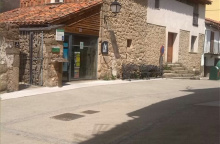
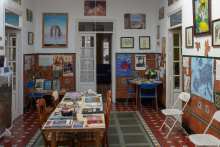
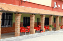
Accommodation in El Culebrín


The streets of Monesterio are paved with cured ham. The monesterienses celebrate the día del jamón, and the local town hall has built a wonderful, incredibly informative, and free museum in its honor. Make time to go and you will get the inside scoop on where to find the best jamón tasting spots in town.
A new type of trail marker appears for the first time near Monesterio. It is a square bollard which depicts a Roman arch and pathway, is painted with two colored stripes, and is meant to indicate that you are following along a Roman road.
WARNING: The road beyond Monesterio is again a long one without water, be certain to carry enough with you.
The camino through Monesterio keeps along the N-630 but there are a few arrows which direct you left and into the town and the municipal albergue. At the far end of town, the camino leaves the N-630 by turning left just after the football field.
This stretch of the camino is poorly waymarked and at times there are conflicting signs; follow the yellow arrows when they are. The camino passes the Arroyo del Bodión (13.2km). Entering Fuente de Cantos there are far too many arrows, which isn’t particularly helpful given that the town is a knot of narrow streets. If you are trying to get to the albergue, follow the arrows to the left when you get to the edge of town. The albergue is located in the south-west corner and from there another set of arrows will deliver you to the correct exit point for the city.
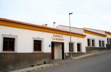
Accommodation in Monesterio
| Albergue Las Moreras 12€ 50 |
|
| Albergue parroquial de Monesterio 10€ 12 |

|


Situated directly on the camino, the Iglesia de Nuestra Señora de la Granada is a fine example of baroque architecture and a smart way to beat the heat while taking in a bit of culture.
There are as many marked routes through town as there are pilgrims to follow them, it is a bit of a mess. Follow whichever set you can find carefully and they will eventually exit the north side of town (NOT along the N-630) onto another farm track. It is level walking all the way to Calzadilla de los Barros.
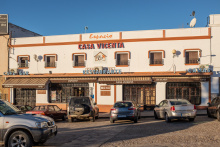
Accommodation in Fuente de Cantos


Pass straight through Calzadilla and pick up the farm track once again. It returns to the road but only for 500m before it turns left sharply away from the road to return to farm tracks all the way to Puebla de Sancho Pérez, passing the Arroyo Atarja (4.7km).
Accommodation in Calzadilla de los Barros
| Albergue Juvenil de Calzadilla de los Barros 6€ 36 |
| Pensión Los Rodríguez | 
|

After passing the Plaza España and Ayuntamiento (Town Hall) the camino passes to the right of the Iglesia de Santa Lucía and heads straight to join the BA-160 out of town. It bears left after passing a gas station to follow a smaller paved road into Zafra.
Accommodation in Puebla de Sancho Pérez
| Hostal El Monte | 
|


The albergue Van Gogh is run by volunteers who promote the Vía de la Plata and their rooftop terrace is the perfect place to wrap up an evening of exploring the old town.
The Museo Santa Clara (adjacent to the convent) is donativo and has a fine collection of medieval artifacts and art.
To the north of the museum, in the heart of the old town, are the humorously named Plazas Grande and Chica. Neither are magnificent, but both are lined with tables and chairs for a late afternoon refreshment.
A whopping 221 of Zafra’s inhabitants joined Hernando de Soto on his journey to the New World in 1539.
The camino through Zafra crosses most of the important landmarks. It enters town near the train station (if you arrived by train, leave the station and turn right) and follows the boulevard straight towards the Plaza España and the large Parque de la Paz. It turns left at the Plaza (before the Parador/Castle) and crosses it diagonally, and on the far end it turns right onto Calle Sevilla (a pedestrian road). From here it passes through the Plaza Grande and makes a right hand turn onto Calle del Conde de la Corte. It will pass through one small triangularly shaped plaza and then exit the old part of town onto the Calle López Asme. From here turn left (the Convento Albergue is ahead on your right) and then right at the Convento Albergue. From here it is straight to and across a roundabout on the N-432. After passing to the left of a housing development the camino returns to the countryside.
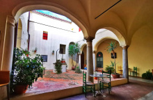
Accommodation in Zafra
| Albergue de Peregrinos Van Gogh Zafra 10€ 40 |
|
| Hostal Carmen ⭑⭑ Booking.com |

|


| Parador de Zafra ⭑⭑⭑⭑ Booking.com |

|

Pack extra water when leaving Los Santos de Maimona, the next source is 15km away.
The arrows bring you through Los Santos, but near the albergue they are not too clear. In fact, they pass behind the albergue which sits like a walled island between two small roads. It returns to the countryside for a long (15km+) road to Villafranca.
Accommodation in Los Santos de Maimona
| Albergue Turístico Vía de la Plata de Los Santos de Maimona 8€ 12 |

|
| Pensión Sanse II Michey | 
|
| Hostal Rosa | 
|

Accommodation in La Almazara
| Albergue Turístico La Almazara 15*€ 28 |
|

Villafranca de los Barros is a large city with all of the services you could need, including 4 albergues for pilgrims.
The stretch of the camino between Villafranca and Torremejía includes a long straight gravel section which is an original Roman road. It makes a few minor twists and turns but eventually heads directly into, through, and out of Torremejía.
Accommodation in Villafranca de los Barros


The stage between Villafranca de los Barros and Torremejía 26.5km can be shortened by making a detour to the nearby city of Almendralejo. This alternate route turns left off of the camino along the long straight section of the former Roman road.


Most services are located on the N-630, which runs parallel to the camino two streets to the west (your left).
If you made your way to the N-630 while in Torremejía there is no need to retrace your steps. Follow it out of town and you will rejoin the camino which emerges from your right. If follows adjacent to the road before arrows and a bollard direct you towards a path on your right. It passes the Ence Mérida factory and heads straight to the outskirts of Mérida where the arrows are a bit unclear. When you emerge onto the road you will see ahead of you a bridge over the river; you need to follow the trail (not the road) which passes underneath that bridge. It leads directly to a small riverside park and at the end of the park is the pedestrian bridge over the río into Mérida.
Accommodation in Torremejía
| Albergue Rojo Plata 16€ 24 Booking.com |

|
| Hostal Milenium Booking.com |

|
The Puente Romano (Roman bridge) over the Río Guadiana carried cars as recently as the early 90’s before being retired to pedestrian use only. It remains the longest surviving ancient bridge and from the entrance, at the park, it is over 400m to the other side.
Once over the bridge the camino immediately turns left to follow a path along the river, avoiding altogether any meaningful entrance into the city of Mérida.

The land where Mérida stands has been inhabited since prehistoric times, but it is the Romans who have made the most lasting impact. In 25 B.C. it was known as Emerita Augusta and together with Astorga (Asturica Augusta) it formed the original Vía de la Plata, an important route used to transport gold from the northern mines to the capital.
To see most of what Mérida has to offer, you’ll need to step off the camino after it crosses the Puente Romano. Immediately after the bridge, looming large on your right, is the Alcazaba, a 9th century Islamic fort (paid). Continue up the Calle Cava to the far end of the Alcazaba and turn left when you see the Burger King, across the plaza is the unassuming DCo-Catedral Metropolitana de Santa María la Mayor. Return to the BK and once past it turn left up Calle Romero Leal which you can follow to the Templo de Diana (free). The portico from the Templo is 100m further up the road at the FPórtico del Foro Municipal.
Keep on this road until it meets Calle José Mélida and then turn right towards the spectacular Teatro Romano and Amphitheater. These two structures bring history to life, the theater is still in use during the summers, but gladiators are no longer in fashion so the Amphitheater gets less use. (paid).
Directly opposite the entrance to the Teatro is the Museo Nacional de Arte Romano, which would be worth walking through even if it didn’t have such a fine collection.
The Acueducto de Los Milagros is the last major site, located on the camino as it leaves the city.
The camino does not make any real entrance into the oldest parts of Mérida and with the exception of the Alcazaba (the castle at the end of the bridge) and the Acueducto de Los Milagros it avoids passing any of the most significant buildings in the city.
From the shadow of the aqueduct, the camino proceeds northward to a set of roundabouts. At the first roundabout it bears left, and at the second roundabout, it does the same to follow along with the Avenida del Lago to Proserpina.


This remarkable aqueduct once carried water into Mérida from the Embalse de Proserpina 5km away.
From the shadow of the aqueduct, the camino proceeds northward to a set of roundabouts. At the first roundabout it bears left, and at the second roundabout, it does the same to follow along with the Avenida del Lago to Proserpina.

Most of Proserpina sits to the east of the camino, but there is a restaurant along the road before the embalse and a few more after it.
The Roman built dam here still stands and is still in use, though no longer does it supply water to the aqueduct in Mérida.
The camino follows a paved road away from the embalse for 4km before turning sharply left to leave it (just before a bridge turns right). From here it follows a path for another 3.5km into El Carrascalejo.


The bar adjacent to the church maintains irregular hours.
The camino climbs gently up to the village, passes counterclockwise around the church, and down the hill to the left and past the albergue. It passes beneath the A-66 before arriving at Aljucén.
Accommodation in El Carrascalejo
| Albergue El Carrascalejo 12€ 24 Booking.com |
|

There is a shop, but the opening hours (10-14) make it impractical. Both bars do food. There are Roman baths open to the public which offers pilgrim discounts.
The camino follows a paved road out of town and joins the N-630 before crossing the Río Aljucén. Once over the river, it leaves the road (before the gas station) to follow a long path through the countryside.
Along the way to Alcuéscar, there are two detours. The first is to the Basílica de Santa Lucía del Trampal but it is not well signposted. From the Basilica you can simply follow the road 3km to Alcuéscar. Of course, if you are not comfortable with the trails and signage you can always walk that same road from Alcuéscar to visit the 8th-century temple. Admission is free (but closed on Mondays) and there is a small exhibition explaining the archeological findings.
The second detour is mentioned below.
Accommodation in Aljucén
| Albergue San Andrés 12€ 24 |
| Casa Romana Aqua Libera ⭑⭑⭑⭑ Booking.com |

|


The signage for the accommodation and restaurant at Las Herrerías is unofficial and somewhat misleading. Just know that it is a detour to the left and that the official camino and Alcuéscar are to the right.
If you made this detour, follow the main road (the EX-382) in the direction of Alcuéscar.
Accommodation in Detour to Cruce de Las Herrerías
| Hostal Canuto | 
|

There are no arrows in town since the camino enters along the road and leaves town at the Casa de Beficiencia. If you have the afternoon energy and have not seen the town get out there and take a stroll. If you fancy an extra 6km along a quiet road, keep an eye open for signs to the Basilica.
The camino leaves town at a left turn just after the albergue. It is a paved road which gives way to a dirt road to follow through the countryside to Casas de Don Antonio.
Accommodation in Alcuéscar
| Apartamentos Rurales Casa Grande | 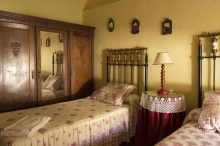
|

The camino completely bypasses the small village, you will need to step away from the marked trail to get to the small bar/shop located in the local social center.
Beyond Casas de Don Antonio the camino returns to the N-630 but follows a path adjacent to it. It crosses the N road and begins to veer away from Aldea del Cano.


Located 500m off of the camino. Ask for the key to the albergue in the bar next door (Las Vegas).
If you stayed in Aldea del Cano, take the road adjacent to the albergue to return to the camino. It follows country roads again, passes under the motorway, and over the Aeródromo de la Cervera. When it gets to the Río Salor take the left-most bridge straight to Valdesalor.
Accommodation in Aldea del Cano
| Albergue Miliario del Verdinal 6€ 12 |

|
| Casa Rural Vía de la Plata Booking.com |

|
The albergue is one of the first buildings in town, instructions for getting the key are on the door... generally located at Ayuntamiento or the Hogar de Penionista. Early morning coffee available at the gas station when leaving town.
The camino leaves town along the N-630 for a short distance. At the Repsol gas station, it turns towards the right to cross over the motorway. It climbs gently to the Puerto de las Camellas (4.9km). The path is soft until the suburbs of Cáceres begin.
The camino enters the old town of Cacéres from the east.
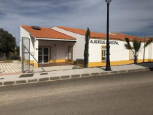
Accommodation in Valdesalor
| Albergue de Valdesalor 6€ 14 |

|

When passing through Cáceres, go slow through the old town. It is small but is packed with the majority of the popular sites. The camino enters via the Arco del Cristo (1st century Roman), one of the few remaining gates to the original wall. Just uphill from the gate is the Casa/Museo de Arabe, which offers a glimpse of what life was like for a wealthy Muslim living in the 12th century. The first plaza you come to is the Plaza de San Jorge, and the church on the opposite end is the Iglesia de Preciosa Sangre (Precious Blood). The tower of the church can be climbed.
From the Plaza de San Jorge the camino veers towards the right, passing through a series of interconnected plazas to arrive at the Catedral de Santa María de Cáceres. If you don’t make it inside, at least rub the toes of the bronze statue outside. They belong to San Pedro de Alcántara and the fact that they are so shiny is a testament to the local belief that rubbing them brings good fortune to your love life.
At this point, the Plaza Mayor (many restaurants, and several towers) is due west and to get there you only need to take the road to your left and through the archway. The camino follows a different path, to the right, to make a wide loop around the old town so that it can pass the Iglesia de Santiago.
The best landmark for exiting Cáceres is the bull ring, where the arrow visibility increases. Cross the main road at the bull ring and follow the signs to Casar de Cáceres, you will quickly find yourself leaving town along a divided collonade with trees for shade. The pedestrian walk ends and the camino follows along the road to a large roundabout. Cross to the left and follow the roundabout clockwise. Be sure NOT to follow the N-521. You are looking for the smaller CC-38. Along the way keep an eye out for arrows which take you away from this busy road to enter Casar de Cáceres along a much quieter path.
Accommodation in Cáceres
| Albergue Municipal Ciudad de Cáceres 16€ 60 |

|
| Albergue turístico Las Veletas 16+€ 30 Booking.com |

|
| Pensión Zurbarán | 
|


Plenty of food choices along the camino, and opportunities for shopping as well. The local swimming pool is a good way to cool down. The Museo del Queso is small and has a bit of charm, but leaves a bit to be desired after the jamón of Monesterio.
PACK WATER. The camino ahead is through remote pastures with little opportunity to refill.
The camino leaves Casar de Cáceres along the road to the north. It almost immediately turns to dirt and continues through the countryside. Along the way, you will pass beside and through walled pastures. It is a quiet stretch of road which, when dry, is rather enjoyable. It is remote, and the only signs of civilization along the way are a few farms and the ongoing construction of the AVE rail line.
You are approaching a large embalse (reservoir) and there are two large bridges which take you over two of the rivers that feed into it. The first is the Río Almonte (17.8km) and the second is the Río Tajo (3.5km). After this second crossing, the camino turns sharply uphill and to the right to leave the road. Opposite the road from this turn is the detour described below.
Accommodation in Casar de Cáceres
| Albergue Municipal de Casar de Cáceres 5€ 22 |

|
| Albergue Turistico Ruta de la Plata Casar 24€ 20 Booking.com |

|


There is a municipal albergue down the road, it is a wonderful new building with an excellent view but also with a history of problems related to its construction which make it hard to predict if it will be open for the season. It is included here for the sake of completeness, but you are advised to check ahead.
Rejoin the camino at the road, making sure to follow the trail upwards and not the road downwards.


The albergue in Alcántara is closed, making this detour less common.

Note that the albergue here is closed indefinitely and that a private Hostel exists.
Beyond Cañaveral the camino offers several options, though they are not presented anywhere and you are most likely to just follow the arrows as you find them and that is OK. This first arrow is just a few hundred meters out of town and takes you to the left and uphill; they look mighty official but locals explain that they were painted by a German cyclist. To get to the second set of arrows just keep on the road to the first roundabout (quite possibly the only roundabout in the world with a chimney) and take it to the left following the N-630. The second set of arrows will take you off the road to your left and past the Ermita de San Cristóbal.
One more word of caution is in order. Be sure to follow the camino markers here and not any of the other popular hiking trails. You will cross a few major roads near a junction with a large CLUB.
8km from Cañaveral the camino is signposted with an optional detour to the small town of Grimaldo.
Accommodation in Cañaveral
| Albergue Turístico Hostel Cañaveral 16€ 20 Booking.com |
|
| Posada La Campana Booking.com |

|
| Hostal Málaga |

Located off the camino, 700m to get there.
9km from Grimaldo, at a place called Cuatro Términos, the camino is signposted with a second option to Riolobos. Note that Riolobos is no longer on the camino and is a rather large detour. Continue straight instead.
Located off the camino. 700m to get there. Upon returning to the camino, you will still have an opportunity to take another optional detour via Riolobos.
Accommodation in Grimaldo
| Albergue Municipal de Grimaldo Donativo€ 12 |

|
| La Posada de Grimaldo | 
|
Accommodation in Riolobos
| Camping Las Catalinas Booking.com |

|
| Casa Rural La Troje | |
| Casa Rural Abuela Maxi 20€ Booking.com |

|

Take some time to explore the well-preserved walls of Galisteo, there are a few shops and a bank within them but the highlight is the ability to walk atop them; an adventure which sounds simple enough but which is not for anyone with wobbly legs and a fear of falling from high places.
The Iglesia de la Asunción is near the eastern gate and is a bit of an anomaly for not being oriented to the east.
From the albergue return to the main road and exit town by walking uphill past the walled part of town, keeping it to your right. Arrows bring you to the Río Jerte (1.7km) and the Puente Romano which crosses it.
From the river, the camino climbs to a pair of roundabouts which straddle the motorway. It is paved walking to Aldeahuela del Jerte.
Accommodation in Galisteo
| Albergue Turístico de Galisteo 15€ 8 |
|


Straight through town and out again along the same road all the way to Carcaboso.
Carcaboso can be a bit confusing to find your way around, the village is a knot of narrow streets. From where the camino arrives, head left along the main road for most services. Return to the camino where you left it or otherwise find your way to the Iglesia de Santiago, there are three Roman milarios there from the emperors Trajan and his adoptive son Adrian. Trajan is best remembered as a great promoter of civic projects such as roads.
The way from Carcaboso to Ventaquemada is a return to nature with a few options along the way. The first turn to pay attention to is less than a kilometer out of town where your natural tendency is to always keep on a straight path; the camino turns right at a sign for Finca Bombay (an adventure sports company, in case you are inclined to rent an ebike). Not far beyond that turn is a split, and here both options are perfectly viable. To the left is somewhat shorter, and to the right is a trail marked H1 along the more historic path.
The two options rejoin and continue through the countryside to Ventaquemada.
Accommodation in Carcaboso
| Albergue turístico y de peregrinos Señora Elena 11€ 12 |

|
| Albergue Los Miliarios 18€ 20 |


Identifiable only as a road crossing with a few buildings. The road to your right leads to Oliva de Plasencia. Continue straight to follow the trail to Cáparra.

Off the camino but a handy way to break up the stage. You can return to the camino at Cáparra for a visit.
Accommodation in Oliva de Plasencia
| Albergue Via Caparra Confort 20€ 15 |

|
| Vía Caparra Superior ⭑⭑⭑ Booking.com |

|

Once a Roman City, Cáparra is now and open-air museum that invites you to explore. It is the location of the only remaining quadrifrons gate on the Iberian peninsula, a testament to this location being built at a crossroads. A visitor center and bathroom are at the public entrance.
After periods of heavy rain, inquire about the route ahead. Several river crossings are made difficult by high water. In extreme cases, a detour can be made from Oliva de Plasencia to Villar de Placencia located on the other side of the N-630.
8.4km from Cáparra you will find markings indicating a detour to your right. They point the way to Jarilla (2km) where there is accommodation.

The 3.3km addition is to the roadside Hostal Asturias.
From Jarilla you do not need to retrace your steps. Follow the N-630 and you will rejoin the camino.
Accommodation in Jarilla
| Hostal Asturias Booking.com |
|
The camino follows the road out of town to a roundabout, where you turn right to cross over the motorway. At the roundabout on the opposite side turn left to resume walking along the road all the way to Baños;
Accommodation in Aldeanueva del Camino
| Albergue de peregrinos de Aldeanueva del Camino 10 |
| Albergue La Casa de mi Abuela 13€ 26 Booking.com |
|
| Casa Rural El Caminante Booking.com |
|


Not a town per se, but a large campground with restaurant along the road. From here it is possible to make a side trip (3km) to Hervás, a beautiful hilltop town.
Accommodation in Las Cañadas


Baños derives its name from the abundance of water that flows from the surrounding mountains, and from the thermal waters that spring up here. If you fancy a splurge, head to the balneario for a soak. The mountains are a blessing for the locals, who enjoy a temperate climate because of them. Unfortunately for pilgrims, the same mountains stand in the way of northern passage.
From Baños the camino begins its climb to the Alto de Béjar. It begins along the old Roman road on the east side of town, avoid the temptation/mistake of following the N-630 (though that will get you to both the alto and the Albergue El Solitario). The climb to the alto is fairly steep, but less than 3km.